Showing posts with label nature reserve. Show all posts

Thursday, April 2, 2020

Palak Siring Kemumu - Wisata Alam Yang Scenic

Wisata alam Palak Siring Kemumu, tempat yang sejuk dan bagus untuk bersantai


Mengemudi menuju pedalaman dari humiditas Bengkulu utara, Anda secara bertahap akan melewati area persawahan dan mulai menanjak melewati desa-desa pegunungan yang sejuk dan lembab di sekitar Kemumu, Arma Jaya, kabupaten Bengkulu Utara. Kemumu terkenal dengan daya tarik alamnya yang indah yaitu Palak Siring, sebuah kawasan yang indah, sejuk, dan cocok untuk bersantai dan juga bisa digunakan sebagai base untuk hiking di sekitar sungai kecil yang bersih dan perbukitan hijau di sekitarnya. Jika Anda tidak ingin melakukan hiking, Anda bisa berjalan kaki singkat untuk melihat pemandangan alam yang keren atau berenang (dekat lokasi air terjun Palak Siring) dan menikmati makan siang Anda. Anda dapat bermalam di Palak Siring, atau melakukan perjalanan pulang-pergi dengan mudah dari kota Bengkulu. Sehari di Palak Siring bisa menjadi pengalaman yang menyenangkan. 

Hiking di sepanjang tepi sungai dan melintasi hutan berbukit
Palak Siring Kemumu jarang dikunjungi oleh turis, namun di hari Minggu dan hari libur kawasan ini akan dipadati oleh pengunjung lokal. Sayangnya tempat yang indah ini tidak memiliki fasilitas yang memadai dan mengalami masalah dengan sampah. Tiket masuk per orang hanya Rp. 2.500 (sekitar US $ 0,15), gratis parkir kecuali akhir pekan.

Lokasi: Palak Siring terletak di Kemumu, Arma Jaya, kabupaten Bengkulu Utara, sekitar 62 km (38,5 mil) / 1,5 jam dari kota Bengkulu, atau sekitar 15 menit berkendara dari Arga Makmur. Temukan lokasi wisata Palak Siring di Google Maps.

Note: Selalu berhati-hati saat berjalan di dekat lokasi air terjun. Beberapa jalan setapak dan bebatuan bisa basah dan licin.


Foto-foto dari wisata alam Palak Siring 

Nafas segar dari alam Palak Siring
Pemandangan dari puncak air terjun Palak Siring
Kolam alami yang sejuk dekat air terjun Palak Siring
Anak sungai Palak Siring
Aliran air yang sejuk dan bersih di dekat air terjun
Photos by Adriansyah Putera and Peter Kimball

Monday, January 23, 2017

Gunung Kaba, Suaka Bagi Hiker Di Provinsi Bengkulu

Pemandangan kawah belerang gunung Kaba
Artikel ini terakhir di-update 26 Juni 2021
For the English version click here!

Gunung Kaba atau yang juga biasa disebut bukit Kaba oleh penduduk setempat, memiliki panorama yang indah dan alami dengan temperatur udara yang moderat, gunung ini menawarkan pengalaman inspiratif bagi mereka yang memiliki hobby trekking atau mendaki gunung untuk menikmati pemandangan hutan tropis plus kawah belerang yang spektakuler dan unik. Gunung Kaba merupakan gunung berapi aktif yang berada di dalam kawasan Konservasi Wisata Alam Bukit Kaba yang memiliki luas area13.490 hektar dan diusulkan untuk pengembangan pariwisata di provinsi Bengkulu. 

Pendakian ke gunung Kaba menawarkan petualangan, semangat hiking, dan tantangan fisik melewati pemandangan hijau yang mempesona. Di bagian puncak gunung, terdapat tiga kawah – bukit Kaba (1.952 m / 6.404 kaki), bukit Itam (1.893 m / 6.211 kaki) and bukit Malintang (1.713 m / 5.620 kaki), dua dari tiga kawah tersebut masih aktif. Saat Anda mendaki punggung gunung Kaba Anda dapat mencium bau belerang, ini bukti bahwa kawah-kawah tersebut masih aktif. Nikmati pemandangan spektakuler di sekeliling Anda. Uap tidak henti-hentinya keluar dari 12 retakan tanah, dan sejumlah mata air panas (tidak layak untuk diminum) dapat ditemukan di sekitar kawasan bukit Kaba. 

Pendakian menuju puncak gunung Kaba
PENJELASAN TRACK 
Pendakian ke bukit Kaba dapat ditempuh dari berbagai arah, tapi dua rute yang paling populer yaitu jalur reguler/jalur jalan aspal yang dimulai dari depan pos POKDARWIS dengan menelusuri jalan aspal hingga ke puncak, dan kemudian jalur hutan yang dimulai dari belakang pos POKDARWIS. Para pengunjung diwajibkan untuk melapor dan mengisi buku tamu di pos POKDARWIS sebelum pendakian dimulai. Biaya masuk Rp. 100.000 (sekitar US$ 6,92) untuk wisatawan asing dan Rp. 11.500 (sekitar US$ 0,80) untuk wisatawan domestik, plus asuransi jiwa Amanah Githa untuk satu kali kunjungan sebesar Rp. 1000 (US$ 0.069). Bagi para pengunjung yang ingin berkemah beberapa hari di sekitar puncak gunung, mereka akan dikenakan biaya tambahan. Ada beberapa tempat parkir sederhana di dan di sekitar pintu masuk pos POKDARWIS untuk akses dan kemudahan bagi pengunjung yang ingin menitipkan sepeda motor atau mobil mereka untuk hanya beberapa jam atau bahkan berhari-hari. Biaya parkir Rp. 5.000 (sekitar US$ 0,35) untuk sepeda motor, dan Rp. 20.000 (sekitar US$ 1,38) untuk mobil. Waktu yang baik untuk mendaki Gunung Kaba yaitu di musim kemarau antara bulan Juni – September.
  

Opsi Jalur Reguler
Durasi pendakian: 1 jam 45 menit hingga 3 jam pendakian
Jika pendakian dimulai di pintu masuk pos POKDARWIS, biasanya memerlukan waktu sekitar 2 jam untuk sampai ke puncak melalui jalur reguler jika Anda merasa energik. Ikuti saja jalur jalan aspal, jalur tersebut akan menuntun Anda hingga ke puncak. Durasi hiking tergantung pada kecepatan langkah kaki Anda, kondisi cuaca, dan seberapa sering Anda berhenti untuk beristirahat dan melihat-lihat pemandangan. Durasi yang kami berikan untuk opsi jalur regular adalah perkiraan, karena semua orang berjalan pada kecepatan yang berbeda-beda. Anda sangat disarankan untuk mengambil jalur reguler jika Anda melakukan pendakian di saat/setelah hujan. Saat musim hujan durasi pendakian bisa menjadi lebih lama.

Opsi Jalur Hutan
Anda dapat menempuh rute jalan setapak melalui hutan untuk melihat pemandangan yang lebih indah dan merasakan sensasi trip petualangan. Hiking melalui jalur hutan juga dapat lebih menghemat waktu tempuh dan tenaga Anda dibandikan hiking melalui jalur reguler, tapi jalur hutan ini sangat beresiko jika Anda tidak familiar dengan tracknya dan mencoba melakukan pendakian seorang diri, Anda bisa tersesat di hutan. Para pengunjung yang belum pernah melewati jalur hutan disarankan untuk menyewa pemandu atau ikut mendaki bersama kelompok pendaki lain yang berpengalaman. Anda dapat menyewa seorang pemandu di Pos POKDARWIS dengan tarif Rp. 75.000 (sekitar US$ 5,19). Hati-hati dengan kondisi jalan setapak dan tebing yang licin dan mudah longsor. Jangan ambil jalur hutan di saat/setelah hujan, lebih baik menghindari resiko dari pada Anda menyesal kemudian. 

Butuh tumpangan sepeda motor ke puncak?
Anda harus dalam kondisi bugar untuk mendaki gunung Kaba. Jika Anda tidak yakin bahwa Anda cukup kuat untuk mendaki, Anda bisa naik ojek dari pos POKDARWIS dengan tarif Rp. 60.000 (sekitar US$ 4,15). Untuk menghindari penipuan tarif jasa ojek dari orang-orang yang menawarkan jasa ojek, sebaiknya Anda membuat dan memastikan kesepakatan tarif jasa dengan tukang ojek terlebih dahulu sebelum Anda menaiki sepeda motornya dan bayar hanya jika Anda telah sampai di puncak gunung.

Kawah belerang gunung Kaba
Info Tambahan Gunung Kaba:
Elevasi puncak: 1.952 m (6.404 kaki)
Koordinat: 3.52 S, 102,62 E
Tipe gunung: stratovolcano (gunung berapi kerucut/komposit)
Erupsi terakhir: 26 -27 Agustus 2007

Lokasi: Dusun Sumber Urip, kabupaten Rejang Lebong, provinsi Bengkulu. Untuk menemukan lokasi gunung Kaba di Google Maps klik di sini!

Petunjuk lokasi secara umum: Gunung Kaba berada sekitar 19 km (11,8 mil) dari Curup ibukota kabupaten Rejang Lebong atau sekitar 104 km (64,7 mil) dari kota Bengkulu. Dibutuhkan waktu sekitar satu jam berkendara dari Curup, 20 menit berkendara dari Simpang Pasar / Simpang Bukit Kaba, atau sekitar 3,5 jam perjalanan dari Bengkulu untuk sampai ke pintu masuk pos POKDARWIS.

Wisatawan asing sedang menikmati pemandangan kawah
Ayo Dukung Responsible Tourism!!
Jika Anda akan bermalam di puncak gunung Kaba (secara lokal dikenal juga dengan nama bukit Kaba) jangan lupa membawa kompor sehingga Anda tidak perlu menguras pasokan kayu bakar yang terbatas. Ketergantungan pada kayu bakar untuk keperluan memasak dapat menyebabkan terjadinya deforestasi/penggundulan hutan yang cepat. Jika Anda terpaksa menyalakan api, gunakanlah perapian yang sudah ada. Gunakan hanya cabang atau ranting pohon yang sudah mati. Pastikan bahwa Anda benar-benar memadamkan api setelah digunakan. Jangan meninggalkan sampah-sampah Anda dan pastikan orang lain di kelompok Anda melakukan hal yang sama. Mari kita dukung "Resposible Tourism" (Pariwisata yang Bertanggung Jawab)!!!!


Jangan gunakan foto-foto dari blog ini untuk tujuan apapun tanpa izin dari saya. Jika Anda ingin menggunakan foto-foto di blog ini silahkan email ke kurt_reyhans@yahoo.com 


Ekstra foto dari gunung Kaba


Gunung Kaba menawarkan jalur trekking yang menakjubkan 
"Gunung-gunung sedang memanggil, dan saya harus pergi." - John Muir


Gunung Kaba dikelilingi oleh lautan topografi hijau 
Menikmati pesona pemandangan gunung Kaba
Puncak gunung Kaba yang berkabut
Hiking bersama keluarga
Puncak gunung Kaba mengepulkan uap panas
Perhatikan dan puaskan sisi petualangan mu di gunung Kaba!
Pendakian Gunung Kaba - bersama kita bisa

Kontak: kurt_reyhans@yahoo.com
Foto: Adriansyah Putera, Peter Kimball, Jeff Clairmont 
Referensi tambahan: John Seach. “Kaba Volcano”. http://www.volcanolive.com/kaba.html


Sunday, October 30, 2016

Lake Suro Offers Scenic Places to Paddle and Explore

Lake Suro in the late afternoon
This post has been updated on July 14th 2018

     As Kepahiang district is still struggling to warm up, it looks more and more inviting as one of road trip gateways in Bengkulu province which is filled with beautiful and fascinating natural features. When visiting Kepahiang district for one day or more, you must include at least a visit to the lake Suro. The lake Suro (locally known as danau Suro) is truly one of the hidden gems in Kepahiang district. There is so much natural beauty around the lake Suro has to offer, whether you want to just wind down and soak up the views or enjoy some of the outdoor activities on and off the water. 

Fun Things to Do
     For an interesting and fun experience of the lake Suro life and its surrounding rainforests, try to visit here either early or late in the day. If you just want to enjoy the attractive natural surroundings from water, take a refreshing river raft tour for Rp. 10,000 per person (about US$ 0.70 - July 2018) from the dock near the entrance. If you love kayaking, bring your kayak along, the lake Suro which also known as “Wisata Musi Indah” offers scenic places to paddle and explore. Don’t forget to take your camera to capture your personal experience, the lake and river activity. 

A hanging bridge to the off the beaten path hikes
     Tired of visiting water-based attractions? Try some of the off the beaten path hikes! For those who love hiking and nature walk, the villages and the surrounding forests near the lake Suro offer fun nature walks which will allow you to touch and look at the beauty of nature, and develop a strong connection with the local natural environment as you walk along the trails. Keep in mind that many of trails are rather challenging and it is recommended to take a guide or a GPS for hikers who want to venture into the forest interior. Ask the guards or the small restaurant owner near the main entrance if you need a guide.

Entrance & Parking Fee
     There is a per vehicle entrance and parking fee, Rp. 5,000 (about US$ 0.35) for a motorcycle and Rp. 10,000 (about US$ 0.75) to Rp 20,000 (about US$ 1.39) for a four- (or more) wheeled vehicle depending on the number of passengers. Legal permits are not required for regular noncommercial day hikes.

Warning: visitors need to be careful when trying to cross the hanging bridge near the entrance as the walkway is poorly maintained, there are too many broken planks. Take a guide for hikers who want to venture into the forest interior! 

Location: the lake Suro is near the Musi Ujan Mas hydroelectricity plant about 16 km (10 mi) from the city of Kepahiang or about 70 km (43 mi) from Bengkulu city. Find the Danau Suro location on Google Maps.

The lake Suro and its surrounding rainforests

     Hope this post can help you plan your trip and get an idea about one of the places you should think about exploring in Kepahiang district. Happy travels!!!!!

Let’s help each other!
     Let’s make this post available in various languages! Translating this post can help more readers in your language to understand this post. If you would like to translate this post into your language or if you need help to translate some of your posts into Indonesian, please send me an email to kurt_reyhans@yahoo.com

Text and photos by: Adriansyah Putera

Wednesday, October 14, 2015

Lake Mas Bestari - Fun Nature Walks

It offers fun hikes with gorgeous mountain views
This article has been updated on June 29th, 2021
Lake Mas Bestari which has complete name lake Mas Harun Bestari is a small lake located in a nice location where visitors can easily get there from Curup and Lubuk Linggau or to some of the nearby sites they want to visit. The lake is surrounded by gorgeous views of Bukit Barisan Mountains. There are simple -mid range hotels near the lakeside for those who want to escape the city for a night or two. 

Mas Bestari lakeside has some good places to relax for visitors. For those who love hiking, the surrounding area of the lake offers a scenic hike (around 3 km/1.8 miles, easy hike) along the lakeside and the rows of hilly vegetable gardens. Early morning or late afternoon when the air is pleasantly cool is the best time for lakeside walks or hikes. It usually takes around an hour or so to hike around the lake. It is possible for visitors to rent a boat for boating the surroundings of the lake. Also, don’t miss another pleasure, capture beautiful sunrise/sunset images from the lakeside or from one of the surrounding hills! You have to go home with nice images and a smile spreads across your face, post-process your images to produce really sweet images, and then upload them. 

Mas Bestari lakeside at sunrise
Location: It is located at the village of Karang Jaya, Kecamatan Selupu Rejang, Rejang Lebong district. Just go through Jalan Raya Curup – Lubuk Linggau around 18 km (11 miles) from the hill town of Curup, or around 2.5 hours drive from Bengkulu. To show the lake location on Google Maps click here!

Parking fee is Rp. 5,000 (US$ 0.34) for car.


More photos from my trip
Fun early morning hike at Mas Bestari lakeside area
Lake Mas Bestari at sunset

Photos by Adriansyah Putera and Sirly Utama

Monday, September 16, 2013

Lake Dendam Tak Sudah

Lake Dendam Tak Sudah - Bengkulu
Last updated: February 2nd 2017

This small lake is located within the Dendam Tak Sudah nature preserve around 8 km (5 miles) of the Bengkulu city center. Dendam Tak Sudah nature preserve covers an area of 5.8 sq km, at an altitude of 15 m. The lake is surrounded by views of both Bukit Barisan mountains and countryside. It is home for rare water orchid called “Vanda Hookeriana” which also known as pencil orchid, and other unique floras. When those plants are blooming, the lakesides would be more awesome views.
Refreshing & nutritious young coconut 

It is a good place to relax, the air is pleasantly cool. It is possible to ask a local fisherman for boating the surroundings of the lake. Also, don’t miss another pleasure, get some jagung bakar (roasted corn) and kelapa muda (young coconut), the fresh juice drunk straight from a young coconut, bought at roadside around the beach. Drink the water and then scoop out the flesh. So far, the lake has not been Bengkulu’s main attraction for foreign travelers.

Getting there
To get to the lake take a yellow, green or red angkot (public city transport) to Terminal Panorama for Rp. 4,000 (about US$ 0.30) then red one C3 to the lake Dendam. You should tell the driver where you’re going before get on. And you should have exact change for the fare (Rp. 4,000) regardless of the distance and anything the drivers may tell you.

Location: Jalan Danau, Dusun Besar, Bengkulu. Click here to find the location on Google Maps!
Cons: not enough parking space and inconvenient for independent travelers.

A good place to relax

Sunday, June 23, 2013

Bengkulu to establish biggest Rafflesia center in Asia

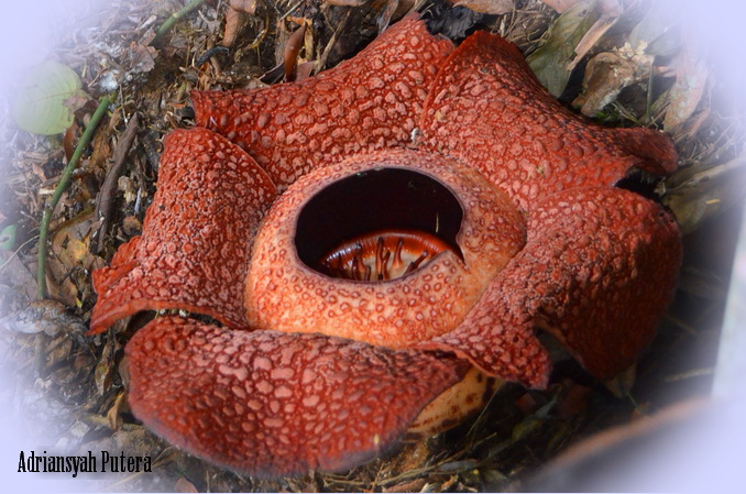
Rafflesia arnoldii
The Bengkulu Tourism and Culture Agency will establish a center to exhibit various types of its rare giant flower the Rafflesia. 

Bengkulu Tourism and Culture Agency head Hasanuddin said on Monday that the exhibition center would be built in two locations in Taba Penanjung, Central Bengkulu, and on Jl. Bencoolen in Tapak Paderi. The center would be established upon two hectares of land and expected to cost Rp 4.5 billion (US$468,018).

“We will propose the establishment of the center to the Tourism and Creative Economy Minister on Tuesday,” he said, adding that the center would be the biggest in Asia.

Tourists usually have to go to the Rindu Hati conservation forest in Kepahiang regency to hunt the foul-smelling flowers that bloom only once a year. The Rafflesia exhibition center is expected to make it easier for tourists who want see the flowers.

According to a researcher from Faculty of Agriculture at Bengkulu University Agus Susatya, there are 25 varieties of Rafflesia in the world, 11 of which can be found in the Sumatra rainforest including in Bengkulu.(cor)

A Rafflesia arnoldii in full bloom

Original source:
Nurni Sulaiman, The Jakarta Post, Bengkulu | Archipelago | Mon, December 10 2012
http://www.thejakartapost.com/news/2012/12/10/bengkulu-establish-biggest-rafflesia-center-asia.html

Photos by: Adriansyah Putera

Saturday, June 1, 2013

Natural Beauty of Bukit Daun

Bukit Daun at sunset
Last updated: January 21st 2017

Seeing Rafflesia arnoldii
       Another area of awesome natural beauty in Bengkulu province, Bukit Daun is a nature conservation surrounded by mountains on all sides and rich with traditional Rejang culture. It is home to endangered species such as, honey bear, Rafflesia arnoldii, the world’s largest flower, and Amorphophallus titanium (locally known as bunga Kibut), the world’s tallest flower. Many kinds of orchid could be found here, too. It is at 800-900 m above sea level, the best way to explore the village is on foot. The air is cool and clean, and the locals are hospitable.

Besides natural beauty, Bukit Daun also offers some great do-it-yourself trekking opportunities where you can explore the fresh and clean outdoors and meet hospitable locals, and stunning sunrises. There is a small Japanese WWII bunker which is constructed of rebar-enforced cement and stone in Bukit Daun. You could also day-trip here for some hiking through forests/coffee plantations and a local lunch. There aren’t any real restaurants in Bukit Daun and most visitors end up having meals and drinks in warung (simple food stall). Basic supplies are available in local shops.

Getting there:
Bukit Daun nature conservation is about 48 km (30 miles) from the city of Bengkulu and can be reached on day trips from Bengkulu, Curup or Kepahiang. Simply take a public transport (Rp. 10,000) to Tebat Monok from Terminal Nakau in Bengkulu or rent a Kijang. 

More photos

The bloom of Rafflesia arnoldii in Bukit Daun nature conservation

Fun hiking through Bukit Daun forest
Japanese WWII bunker
Foggy scenery of Bukit Daun

Photos by Adriansyah Putera and Shirley Utama Adriansyah

Thursday, April 18, 2013

Panjang Beach Bengkulu

Panjang beach at sunset
     Bengkulu’s main beach, Pantai Panjang, stretches for approximately 7 km (4.4 miles). It is located on the Indian Ocean, western coast of Bengkulu city, about 2 km from Suprapto shopping center. The beach has white sand and pretty good surf. Early morning on a mid to high tide will be the best time for a surf. It is the most popular beach for the local beach goers.

Delman (horse drawn vehicle)
You can find seaside cottages, nice hotels, shopping centers, warung-warung (street stalls) and night clubs along the beach. Other recreational facilities are also available such as: swimming pools, fishing ponds, etc. At the beach (right in front of Pasir Putih cottage) you can try a delman (horse drawn vehicle). The delmans are only available on every Sunday, and every national public holiday. Also, don’t miss another pleasure, kelapa muda (young coconut), the fresh juice drunk straight from a young coconut, bought at roadside around the beach. Drink the milk and then scoop out the flesh. If you enjoy the taste of young coconut water and can tolerate large amounts, it could help keep you hydrated. Unfortunately this beautiful beach still needs more and better supporting facilities, and also litter is a major environmental problem on the beach, litter is often left by the beach goers.

How to get there?
You can take a yellow angkot (city transport) from Jl. Suprapto or along its route to the beach center gate for Rp. 4,000 per one person. There is no entrance fee, except during Eid al Fitr public holiday also known as Lebaran, and Eid al Adha public holiday or Lebaran Haji, the visitors are charged for Rp. 1,000 per one person. If you are visiting by car, a parking fee of Rp. 3000 will be required.  

Warning: The beach has big waves which are kind of good for surfing, but be careful, it’s rarely suitable for swimming; it’s unsafe for swimming too far out because there are strong currents in some spots.

More photos of Panjang beach
Enjoying the sunset at Panjang beach Bengkulu
A nice late afternoon at Panjang beach
The most popular beach in town 
Panjang beach at sunset
Coconut water could help keep you hydrated.

Photos by Adriansyah Putera

Thursday, April 11, 2013

Palak Siring Kemumu - A Scenic Natural Attraction

Palak Siring Kemumu natural attraction, a cool and good place to relax
Last updated: April 2nd, 2020
Klik di sini untuk versi bahasa Indonesia
     
Driving inland from the humidity of northern Bengkulu, you gradually leave the rice terraces behind and ascend into the cool, damp hill villages around Kemumu, Arma Jaya, North Bengkulu district. The village of Kemumu is known for its scenic natural attraction called Palak Siring, a lovely, cool and good area to relax and use as a base for hiking around the clean small river and surrounding green hills. If you don’t want to do hiking, you can do some short walk to see the cool panorama or swimming (near the Palak Siring waterfall site) and enjoy your lunch. You can stay there or easily day trip from the city of Bengkulu. A day at Palak Siring can be a wonderful experience.

Hiking along the river's edge and through hilly forest 
Palak Siring Kemumu lacks of tourists, though Sunday and public holidays are crowded with local visitors. Unfortunately this beautiful place lacks of adequate facilities and experiences a problem with litter. Admission per person is just Rp. 2,500 (about US$ 0.15), free parking on weekdays. 

Location: Palak Siring is located in Kemumu, Arma Jaya, Northern Bengkulu district, about 62 km (38.5 miles) / 1.5 hours from the city of Bengkulu, or about 15 minutes drive from Arga Makmur. Find the location of Palak Siring on Google Maps

Note: Always be very cautious when walking nearby the waterfall site. Some of the trails and rocks can be wet and slippery. 


More photos from Palak Siring Kemumu

The view from the top of the Palak Siring waterfall
Palak Siring creek
Cool swimming hole site near the Palak Siring waterfall
The cool and clean water stream nearby
The sweet breathing of Palak Siring nature

Photos by Adriansyah Putera & Peter Kimball